


Locronan

Yannick.Boireau
User
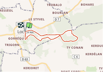

Length
6.5 km

Max alt
283 m

Uphill gradient
171 m
Km-Effort
8.8 km

Min alt
153 m

Downhill gradient
172 m
Boucle
Yes
Creation date :
2023-06-08 11:37:52.481
Updated on :
2023-06-08 14:19:17.971
2h03
Difficulty : Medium

FREE GPS app for hiking
 SityTrail
IGN / Geographical institutes
SityTrail Plus
The world is yours!
About
Trail Walking of 6.5 km to be discovered at Brittany, Finistère, Locronan. This trail is proposed by Yannick.Boireau.
Positioning
Country:
France
Region :
Brittany
Department/Province :
Finistère
Municipality :
Locronan
Location:
Unknown
Start:(Dec)
Start:(UTM)
410042 ; 5327941 (30U) N.
Comments