


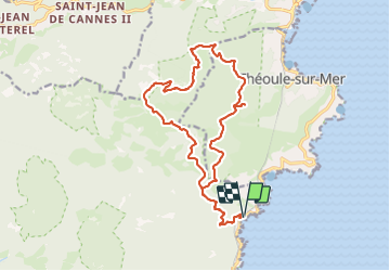
Gare du traya - Mont de théoule - Mont saint Martin

Gilles Auffret
User

Length
19.5 km

Max alt
368 m

Uphill gradient
908 m
Km-Effort
32 km

Min alt
15 m

Downhill gradient
908 m
Boucle
Yes
Creation date :
2023-06-08 05:52:26.0
Updated on :
2023-06-09 07:33:39.852
7h10
Difficulty : Very difficult

FREE GPS app for hiking
 SityTrail
IGN / Geographical institutes
SityTrail Plus
The world is yours!
About
Trail Walking of 19.5 km to be discovered at Provence-Alpes-Côte d'Azur, Var, Saint-Raphaël. This trail is proposed by Gilles Auffret.
Description
Belle randonnée au dessus de Théoule
Attention la descente du Mont de Théoule est dangereuse, Pour l'éviter possibilité de prendre la piste à côté
Positioning
Country:
France
Region :
Provence-Alpes-Côte d'Azur
Department/Province :
Var
Municipality :
Saint-Raphaël
Location:
Unknown
Start:(Dec)
Start:(UTM)
332163 ; 4815563 (32T) N.
Comments