


Vélo(74) - Col de Jambaz - Col du Feu - Col du Perret

HG74250
User
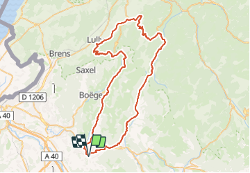

Length
75 km

Max alt
1136 m

Uphill gradient
1898 m
Km-Effort
101 km

Min alt
579 m

Downhill gradient
1904 m
Boucle
Yes
Creation date :
2023-06-12 05:30:14.88
Updated on :
2023-06-12 05:31:33.15
6h06
Difficulty : Very difficult

FREE GPS app for hiking
 SityTrail
IGN / Geographical institutes
SityTrail Plus
The world is yours!
About
Trail Road bike of 75 km to be discovered at Auvergne-Rhône-Alpes, Upper Savoy, Saint-Jean-de-Tholome. This trail is proposed by HG74250.
Positioning
Country:
France
Region :
Auvergne-Rhône-Alpes
Department/Province :
Upper Savoy
Municipality :
Saint-Jean-de-Tholome
Location:
Unknown
Start:(Dec)
Start:(UTM)
299316 ; 5111032 (32T) N.
Comments