


2023-06-12_09h13m25_hpd0052 le tour du P de Murat

Eric Cuny
User
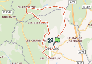

Length
9.2 km

Max alt
554 m

Uphill gradient
197 m
Km-Effort
11.8 km

Min alt
394 m

Downhill gradient
200 m
Boucle
Yes
Creation date :
2023-06-12 07:13:25.726
Updated on :
2023-06-12 07:13:24.765

FREE GPS app for hiking
 SityTrail
IGN / Geographical institutes
SityTrail Plus
The world is yours!
About
Trail of 9.2 km to be discovered at Auvergne-Rhône-Alpes, Puy-de-Dôme, Jozerand. This trail is proposed by Eric Cuny.
Positioning
Country:
France
Region :
Auvergne-Rhône-Alpes
Department/Province :
Puy-de-Dôme
Municipality :
Jozerand
Location:
Unknown
Start:(Dec)
Start:(UTM)
507735 ; 5097008 (31T) N.
Comments