


Thiézac ( Gîte Lafon ) - Lioran

Alain28/01
User
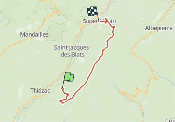

Length
18.8 km

Max alt
1821 m

Uphill gradient
991 m
Km-Effort
31 km

Min alt
983 m

Downhill gradient
734 m
Boucle
No
Creation date :
2023-06-12 12:24:21.733
Updated on :
2023-06-12 12:26:34.678
7h04
Difficulty : Difficult

FREE GPS app for hiking
 SityTrail
IGN / Geographical institutes
SityTrail Plus
The world is yours!
About
Trail Walking of 18.8 km to be discovered at Auvergne-Rhône-Alpes, Cantal, Thiézac. This trail is proposed by Alain28/01.
Positioning
Country:
France
Region :
Auvergne-Rhône-Alpes
Department/Province :
Cantal
Municipality :
Thiézac
Location:
Unknown
Start:(Dec)
Start:(UTM)
476090 ; 4984813 (31T) N.
Comments