


courmont

jacthiry
User
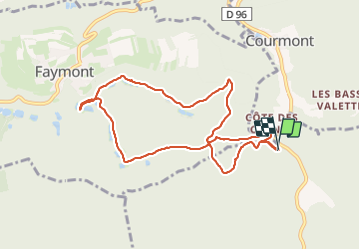

Length
8.7 km

Max alt
439 m

Uphill gradient
249 m
Km-Effort
12.1 km

Min alt
307 m

Downhill gradient
248 m
Boucle
Yes
Creation date :
2023-06-01 12:01:29.441
Updated on :
2023-06-12 13:56:17.284
2h16
Difficulty : Difficult

FREE GPS app for hiking
 SityTrail
IGN / Geographical institutes
SityTrail Plus
The world is yours!
About
Trail Walking of 8.7 km to be discovered at Bourgogne-Franche-Comté, Haute-Saône, Saulnot. This trail is proposed by jacthiry.
Positioning
Country:
France
Region :
Bourgogne-Franche-Comté
Department/Province :
Haute-Saône
Municipality :
Saulnot
Location:
Unknown
Start:(Dec)
Start:(UTM)
321711 ; 5274535 (32T) N.
Comments