


albigny 8.2 à 382 -p 12 06 23

jtraverse
User

Length
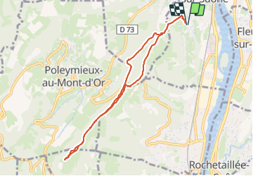
8.3 km

Max alt
594 m

Uphill gradient
381 m
Km-Effort
13.4 km

Min alt
224 m

Downhill gradient
381 m
Boucle
Yes
Creation date :
2023-06-12 10:50:40.088
Updated on :
2023-06-12 14:12:41.704
3h21
Difficulty : Difficult

FREE GPS app for hiking
 SityTrail
IGN / Geographical institutes
SityTrail Plus
The world is yours!
About
Trail Walking of 8.3 km to be discovered at Auvergne-Rhône-Alpes, Métropole de Lyon, Albigny-sur-Saône. This trail is proposed by jtraverse.
Positioning
Country:
France
Region :
Auvergne-Rhône-Alpes
Department/Province :
Métropole de Lyon
Municipality :
Albigny-sur-Saône
Location:
Unknown
Start:(Dec)
Start:(UTM)
641895 ; 5080692 (31T) N.
Comments