


Budapest Citadelle-Battyiany ter

MAUVAGE Patrick
User
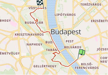

Length
6.5 km

Max alt
219 m

Uphill gradient
212 m
Km-Effort
9.3 km

Min alt
96 m

Downhill gradient
212 m
Boucle
No
Creation date :
2023-06-12 12:24:38.0
Updated on :
2023-06-14 05:20:30.644
1h36
Difficulty : Unknown

FREE GPS app for hiking
 SityTrail
IGN / Geographical institutes
SityTrail Plus
The world is yours!
About
Trail Walking of 6.5 km to be discovered at Central Hungary, Budapest, Unknown. This trail is proposed by MAUVAGE Patrick.
Photos


Positioning
Country:
Hungary
Region :
Central Hungary
Department/Province :
Budapest
Municipality :
Unknown
Location:
5th district
Start:(Dec)
Start:(UTM)
353685 ; 5261156 (34T) N.
Comments