


Randonnée du 14/09/2020 à 10:17

houbart
User

Length
13.3 km

Max alt
361 m

Uphill gradient
538 m
Km-Effort
20 km

Min alt
127 m

Downhill gradient
539 m
Boucle
Yes
Creation date :
2023-06-13 10:47:59.354
Updated on :
2023-06-13 10:51:13.369
4h38
Difficulty : Very difficult

FREE GPS app for hiking
 SityTrail
IGN / Geographical institutes
SityTrail Plus
The world is yours!
About
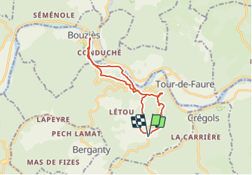
Trail Walking of 13.3 km to be discovered at Occitania, Lot, Saint-Cirq-Lapopie. This trail is proposed by houbart.
Positioning
Country:
France
Region :
Occitania
Department/Province :
Lot
Municipality :
Saint-Cirq-Lapopie
Location:
Unknown
Start:(Dec)
Start:(UTM)
394542 ; 4922523 (31T) N.
Comments