


Clapiers St Bauzille AR

ARVIEU
User
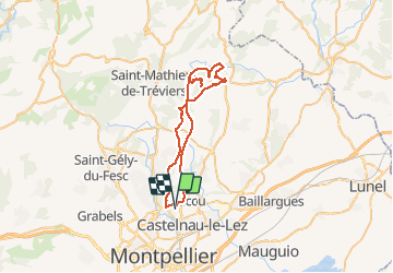

Length
50 km

Max alt
320 m

Uphill gradient
813 m
Km-Effort
60 km

Min alt
49 m

Downhill gradient
816 m
Boucle
Yes
Creation date :
2014-12-14 00:00:00.0
Updated on :
2014-12-14 00:00:00.0
3h56
Difficulty : Medium

FREE GPS app for hiking
 SityTrail
IGN / Geographical institutes
SityTrail Plus
The world is yours!
About
Trail Mountain bike of 50 km to be discovered at Occitania, Hérault, Clapiers. This trail is proposed by ARVIEU.
Description
par la Suque
Positioning
Country:
France
Region :
Occitania
Department/Province :
Hérault
Municipality :
Clapiers
Location:
Unknown
Start:(Dec)
Start:(UTM)
571914 ; 4833937 (31T) N.
Comments