


ile de Bréhat

josy31
User
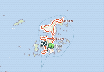

Length
14.4 km

Max alt
29 m

Uphill gradient
188 m
Km-Effort
16.9 km

Min alt
0 m

Downhill gradient
186 m
Boucle
No
Creation date :
2023-06-12 09:43:37.91
Updated on :
2023-06-13 17:57:25.467
5h02
Difficulty : Medium

FREE GPS app for hiking
 SityTrail
IGN / Geographical institutes
SityTrail Plus
The world is yours!
About
Trail Walking of 14.4 km to be discovered at Brittany, Côtes-d'Armor, Île-de-Bréhat. This trail is proposed by josy31.
Description
Très beaux points de vue
Positioning
Country:
France
Region :
Brittany
Department/Province :
Côtes-d'Armor
Municipality :
Île-de-Bréhat
Location:
Unknown
Start:(Dec)
Start:(UTM)
499627 ; 5409482 (30U) N.
Comments