


Budapest Ile Marguerite-Vizivaros

MAUVAGE Patrick
User
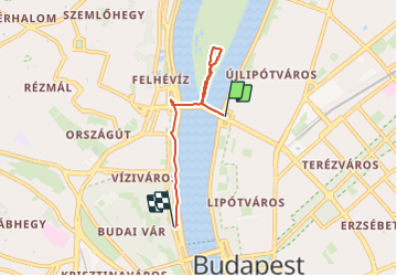

Length
4 km

Max alt
113 m

Uphill gradient
55 m
Km-Effort
4.7 km

Min alt
96 m

Downhill gradient
43 m
Boucle
No
Creation date :
2023-06-14 09:41:12.0
Updated on :
2023-06-29 21:38:22.143
38m
Difficulty : Unknown

FREE GPS app for hiking
 SityTrail
IGN / Geographical institutes
SityTrail Plus
The world is yours!
About
Trail Walking of 4 km to be discovered at Central Hungary, Budapest, Unknown. This trail is proposed by MAUVAGE Patrick.
Positioning
Country:
Hungary
Region :
Central Hungary
Department/Province :
Budapest
Municipality :
Unknown
Location:
13th district
Start:(Dec)
Start:(UTM)
352966 ; 5264087 (34T) N.
Comments