


Wangenbourg Schneeberg

oscar1
User
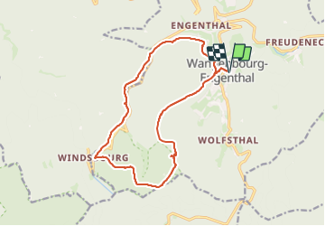

Length
15.4 km

Max alt
956 m

Uphill gradient
616 m
Km-Effort
24 km

Min alt
452 m

Downhill gradient
615 m
Boucle
Yes
Creation date :
2023-06-14 07:13:19.721
Updated on :
2023-06-14 18:45:13.164
5h22
Difficulty : Medium

FREE GPS app for hiking
 SityTrail
IGN / Geographical institutes
SityTrail Plus
The world is yours!
About
Trail Walking of 15.4 km to be discovered at Grand Est, Bas-Rhin, Wangenbourg-Engenthal. This trail is proposed by oscar1.
Photos


Positioning
Country:
France
Region :
Grand Est
Department/Province :
Bas-Rhin
Municipality :
Wangenbourg-Engenthal
Location:
Unknown
Start:(Dec)
Start:(UTM)
375377 ; 5386850 (32U) N.
Comments