


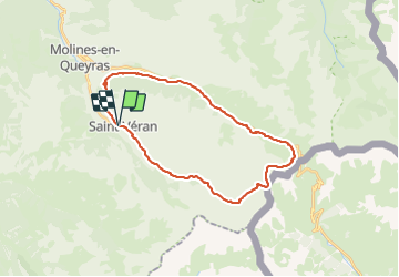
Ref la Blanche, Ref Agnel 1090m+ depuis St Véran

ericberlin
User

Length
28 km

Max alt
2883 m

Uphill gradient
1085 m
Km-Effort
42 km

Min alt
1945 m

Downhill gradient
1092 m
Boucle
Yes
Creation date :
2023-06-14 15:20:38.858
Updated on :
2023-06-14 15:30:08.85
9h36
Difficulty : Very difficult

FREE GPS app for hiking
 SityTrail
IGN / Geographical institutes
SityTrail Plus
The world is yours!
About
Trail Walking of 28 km to be discovered at Provence-Alpes-Côte d'Azur, Hautes-Alpes, Saint-Véran. This trail is proposed by ericberlin.
Description
https://www.refugedelablanche.com
https://www.refugeagnel.com/
Navette à St Véran
https://www.saintveran.com/venir/services/divers/
Photos

Positioning
Country:
France
Region :
Provence-Alpes-Côte d'Azur
Department/Province :
Hautes-Alpes
Municipality :
Saint-Véran
Location:
Unknown
Start:(Dec)
Start:(UTM)
330962 ; 4951772 (32T) N.
Comments