


Bords de Loire entre 2 ponts et villages

Maca8284
User
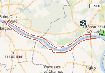

Length
21 km

Max alt
124 m

Uphill gradient
220 m
Km-Effort
24 km

Min alt
93 m

Downhill gradient
204 m
Boucle
No
Creation date :
2023-06-15 07:03:25.113
Updated on :
2023-06-15 13:07:14.461
6h01
Difficulty : Very difficult

FREE GPS app for hiking
 SityTrail
IGN / Geographical institutes
SityTrail Plus
The world is yours!
About
Trail Walking of 21 km to be discovered at Centre-Loire Valley, Loiret, Sigloy. This trail is proposed by Maca8284.
Positioning
Country:
France
Region :
Centre-Loire Valley
Department/Province :
Loiret
Municipality :
Sigloy
Location:
Unknown
Start:(Dec)
Start:(UTM)
442622 ; 5300619 (31T) N.
Comments