


Refuge Ociolu - refuge de Croci

Lobin
User
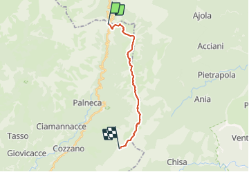

Length
16.5 km

Max alt
1997 m

Uphill gradient
1281 m
Km-Effort
32 km

Min alt
1290 m

Downhill gradient
822 m
Boucle
No
Creation date :
2023-06-13 01:56:35.0
Updated on :
2023-06-15 18:14:07.76
8h33
Difficulty : Difficult

FREE GPS app for hiking
 SityTrail
IGN / Geographical institutes
SityTrail Plus
The world is yours!
About
Trail Walking of 16.5 km to be discovered at Corsica, South Corsica, Palneca. This trail is proposed by Lobin.
Photos


Positioning
Country:
France
Region :
Corsica
Department/Province :
South Corsica
Municipality :
Palneca
Location:
Unknown
Start:(Dec)
Start:(UTM)
516081 ; 4652888 (32T) N.
Comments