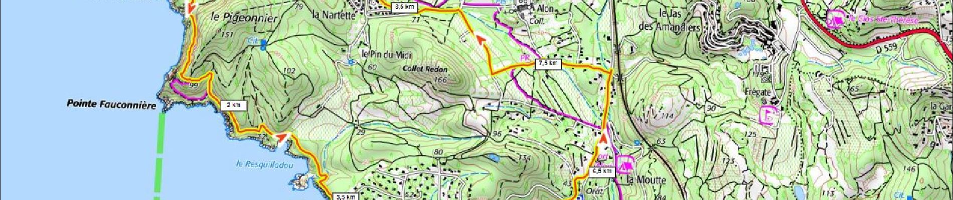
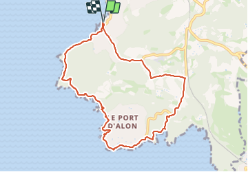
Trail Walking Saint-Cyr-sur-Mer - Port d'Alon 260m+ - Photo
© OpenStreetMap contributors
Length
Length
9.6 km
Max alt
Max alt
95 m
Uphill gradient
Uphill gradient
264 m
Km-Effort
Km-Effort  
13.1 km
Min alt
Min alt
0 m
Downhill gradient
Downhill gradient
263 m
Boucle
Boucle
Yes
Creation date :
2023-06-15 14:18:01.334
Updated on :
2023-06-15 15:21:54.664

(0 Reviews)

Walking
Walking
2h59
Difficulty : Difficult

Scan this QR Code to open this trail in the SityTrail application

FREE GPS app for hiking

Logo SityTrail SityTrail

IGN / Geographical institutes

Download SityTrail from the App Store Download SityTrail from Google Play

Logo SityTrail SityTrail Plus

The world is yours!

Download SityTrail from the App Store Download SityTrail from Google Play Download SityTrail on Huawei AppGallery

About

Trail Walking of 9.6 km to be discovered at Provence-Alpes-Côte d'Azur, Var, Saint-Cyr-sur-Mer. This trail is proposed by ericberlin.

Description

Une classique magifique en corniche.
Bars et restaurants sur le port à la Madrague.
Restaurant en saison à la calanque.
Parkings payants à la Madrague et à la calanque.

L’été, consulter la carte des autorisations d’accès au massifs forestiers dans le 13 en fonction du risque d’incendies :
0811 20 13 13
http://bpatp.paca-ate.fr/

Elevation profile

Photos

Positioning

Country:
France
Region :
Provence-Alpes-Côte d'Azur
Department/Province :
Var
Municipality :
Saint-Cyr-sur-Mer
Location:
Unknown
Start:(UTM)
719027 ; 4782880 (31T) N.


Close
My subscriptions