


PIC SAINT MICHEL

nordan
User
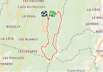

Length
13.5 km

Max alt
1965 m

Uphill gradient
839 m
Km-Effort
25 km

Min alt
1374 m

Downhill gradient
840 m
Boucle
Yes
Creation date :
2023-06-16 08:22:04.978
Updated on :
2023-06-16 14:10:00.349
4h18
Difficulty : Medium

FREE GPS app for hiking
 SityTrail
IGN / Geographical institutes
SityTrail Plus
The world is yours!
About
Trail Walking of 13.5 km to be discovered at Auvergne-Rhône-Alpes, Isère, Lans-en-Vercors. This trail is proposed by nordan.
Positioning
Country:
France
Region :
Auvergne-Rhône-Alpes
Department/Province :
Isère
Municipality :
Lans-en-Vercors
Location:
Unknown
Start:(Dec)
Start:(UTM)
705255 ; 4999169 (31T) N.
Comments