


Montady le camenbert du lac asséché

meillon
User
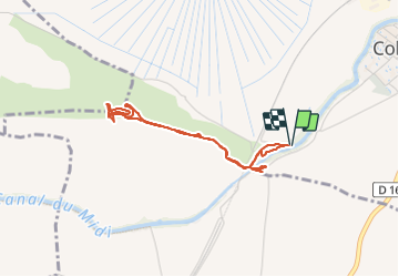

Length
3.9 km

Max alt
118 m

Uphill gradient
97 m
Km-Effort
5.2 km

Min alt
30 m

Downhill gradient
97 m
Boucle
Yes
Creation date :
2023-06-16 13:32:17.256
Updated on :
2023-06-16 15:10:01.982
1h36
Difficulty : Easy

FREE GPS app for hiking
 SityTrail
IGN / Geographical institutes
SityTrail Plus
The world is yours!
About
Trail Walking of 3.9 km to be discovered at Occitania, Hérault, Colombiers. This trail is proposed by meillon.
Description
du canal du Midi à l oppidum d Enserune, point de vue panoramique de la méditerranée au caribou et à la montagne noire....
Positioning
Country:
France
Region :
Occitania
Department/Province :
Hérault
Municipality :
Colombiers
Location:
Unknown
Start:(Dec)
Start:(UTM)
510513 ; 4795089 (31T) N.
Comments