


RA 2023 Mont Saint Michel

dfluzin
User
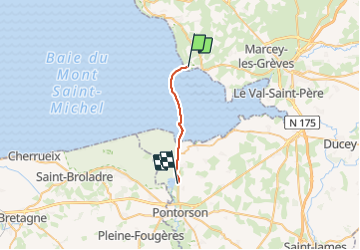

Length
13.9 km

Max alt
16 m

Uphill gradient
45 m
Km-Effort
14.5 km

Min alt
0 m

Downhill gradient
48 m
Boucle
No
Creation date :
2023-06-16 07:52:51.376
Updated on :
2023-06-16 15:15:39.841
5h07
Difficulty : Difficult

FREE GPS app for hiking
 SityTrail
IGN / Geographical institutes
SityTrail Plus
The world is yours!
About
Trail Walking of 13.9 km to be discovered at Normandy, Manche, Genêts. This trail is proposed by dfluzin.
Positioning
Country:
France
Region :
Normandy
Department/Province :
Manche
Municipality :
Genêts
Location:
Unknown
Start:(Dec)
Start:(UTM)
610520 ; 5393756 (30U) N.
Comments