


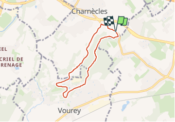
SityTrail - le Ri d'Olon

raymondfn
User

Length
6.2 km

Max alt
364 m

Uphill gradient
169 m
Km-Effort
8.5 km

Min alt
212 m

Downhill gradient
167 m
Boucle
Yes
Creation date :
2023-06-16 18:11:07.88
Updated on :
2023-06-18 09:52:34.016
1h55
Difficulty : Medium

FREE GPS app for hiking
 SityTrail
IGN / Geographical institutes
SityTrail Plus
The world is yours!
About
Trail Walking of 6.2 km to be discovered at Auvergne-Rhône-Alpes, Isère, Charnècles. This trail is proposed by raymondfn.
Positioning
Country:
France
Region :
Auvergne-Rhône-Alpes
Department/Province :
Isère
Municipality :
Charnècles
Location:
Unknown
Start:(Dec)
Start:(UTM)
698776 ; 5023659 (31T) N.
Comments