


Lagarde viaur

Frayssinet
User
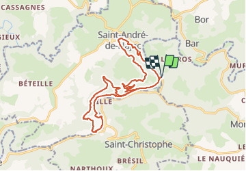

Length
19.7 km

Max alt
408 m

Uphill gradient
534 m
Km-Effort
27 km

Min alt
161 m

Downhill gradient
536 m
Boucle
Yes
Creation date :
2020-06-28 07:31:45.001
Updated on :
2023-06-18 14:00:28.488
6h00
Difficulty : Easy

FREE GPS app for hiking
 SityTrail
IGN / Geographical institutes
SityTrail Plus
The world is yours!
About
Trail Walking of 19.7 km to be discovered at Occitania, Tarn, Montirat. This trail is proposed by Frayssinet.
Positioning
Country:
France
Region :
Occitania
Department/Province :
Tarn
Municipality :
Montirat
Location:
Unknown
Start:(Dec)
Start:(UTM)
424896 ; 4891859 (31T) N.
Comments