


Anglès Les Deveze

Ada11
User GUIDE
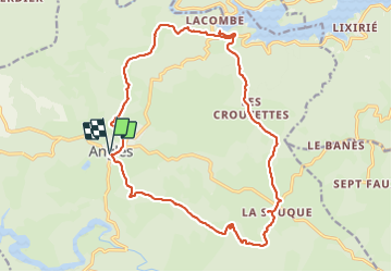

Length
21 km

Max alt
864 m

Uphill gradient
534 m
Km-Effort
28 km

Min alt
679 m

Downhill gradient
535 m
Boucle
Yes
Creation date :
2023-06-18 07:22:38.581
Updated on :
2023-06-18 14:32:04.443
6h02
Difficulty : Medium

FREE GPS app for hiking
 SityTrail
IGN / Geographical institutes
SityTrail Plus
The world is yours!
About
Trail Walking of 21 km to be discovered at Occitania, Tarn, Anglès. This trail is proposed by Ada11.
Description
Assez ombragée. Beaucoup de macadam.
Positioning
Country:
France
Region :
Occitania
Department/Province :
Tarn
Municipality :
Anglès
Location:
Unknown
Start:(Dec)
Start:(UTM)
464509 ; 4823509 (31T) N.
Comments