


Refuge de l'Estrop

Clo0413
User
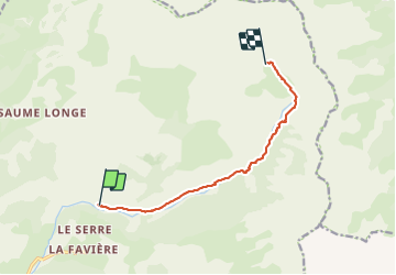

Length
8.7 km

Max alt
2036 m

Uphill gradient
820 m
Km-Effort
17 km

Min alt
1226 m

Downhill gradient
18 m
Boucle
No
Creation date :
2023-06-17 07:54:40.664
Updated on :
2023-06-18 17:27:59.939
2h54
Difficulty : Medium

FREE GPS app for hiking
 SityTrail
IGN / Geographical institutes
SityTrail Plus
The world is yours!
About
Trail Walking of 8.7 km to be discovered at Provence-Alpes-Côte d'Azur, Alpes-de-Haute-Provence, Prads-Haute-Bléone. This trail is proposed by Clo0413.
Positioning
Country:
France
Region :
Provence-Alpes-Côte d'Azur
Department/Province :
Alpes-de-Haute-Provence
Municipality :
Prads-Haute-Bléone
Location:
Prads
Start:(Dec)
Start:(UTM)
298197 ; 4901846 (32T) N.
Comments