


Homps

meillon
User
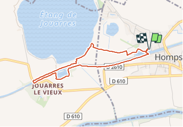

Length
4 km

Max alt
54 m

Uphill gradient
15 m
Km-Effort
4.2 km

Min alt
46 m

Downhill gradient
14 m
Boucle
Yes
Creation date :
2023-06-19 05:14:34.126
Updated on :
2023-06-19 06:30:48.591
1h15
Difficulty : Easy

FREE GPS app for hiking
 SityTrail
IGN / Geographical institutes
SityTrail Plus
The world is yours!
About
Trail Walking of 4 km to be discovered at Occitania, Aude, Homps. This trail is proposed by meillon.
Description
vers le lac du Jouarres en suivant le canal du Midi
Positioning
Country:
France
Region :
Occitania
Department/Province :
Aude
Municipality :
Homps
Location:
Unknown
Start:(Dec)
Start:(UTM)
477066 ; 4790703 (31T) N.
Comments