


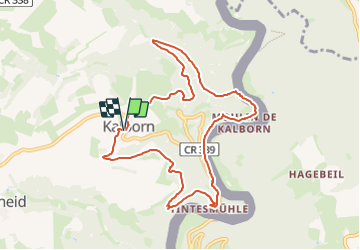
2023-06-19_15h13m51_eislek-pad-kalborn-1

mumu.larandonneuse
User GUIDE


2h45
Difficulty : Medium

FREE GPS app for hiking
 SityTrail
IGN / Geographical institutes
SityTrail Plus
The world is yours!
About
Trail Walking of 9 km to be discovered at Unknown, Canton Clervaux, Clervaux. This trail is proposed by mumu.larandonneuse.
Description
Descendant vers la rivière sauvage
La rivière Our est une importante source de vie pour ses habitants, dont la moule de fontaine. Découvrez l'exposition au moulin de Kalborn. Le point culminant de cette visite le long de l'Our est le point de vue de Kailslee. La rude ascension sera récompensée par une vue exceptionnelle sur la vallée de l'Our.
ℹ️ www.visit-eislek.lu
Positioning
Comments