


2023-06-19_15h18m29_eislek-pad-tadler-1

mumu.larandonneuse
User GUIDE
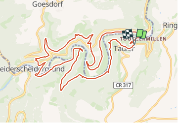


4h25
Difficulty : Difficult

FREE GPS app for hiking
 SityTrail
IGN / Geographical institutes
SityTrail Plus
The world is yours!
About
Trail Walking of 13.4 km to be discovered at Unknown, Canton Wiltz, Esch-sur-Sûre. This trail is proposed by mumu.larandonneuse.
Description
• Le long des méandres de la rivière •
Observez les boucles de la Sûre, parfois de loin, parfois de très près, parfois vous la regardez d'en haut et parfois de côté. Les points de vue Gruewen et Bei der Beetebach changent votre perspective. Ensuite, vous pourrez découvrir la chapelle octogonale St. Kunigunde à Heiderscheidergrund. Celui qui compte les huit virages en premier est le gagnant et peut continuer la randonnée !
ℹ️ www.visit-eislek.lu
Positioning
Comments
route was op 2 plaatsen omgeleid vanwege werkzaamheden. Uitstekend aangegeven vooraf en tijdens wandeling.