


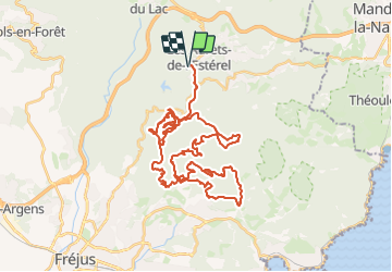
adrets-naline-2022-parcours-vtt-50-km

topolino
User


4h53
Difficulty : Very difficult

FREE GPS app for hiking
 SityTrail
IGN / Geographical institutes
SityTrail Plus
The world is yours!
About
Trail Mountain bike of 52 km to be discovered at Provence-Alpes-Côte d'Azur, Var, Les Adrets-de-l'Estérel. This trail is proposed by topolino.
Description
Adrets'Naline 2022 Parcours Vtt 50 km
Parcours physique, mais magnifique dans ce site exceptionnel de l'Esterel
Points de vue a 360° sur le sommet de la randonnée
organisée avec brio par L'Esterel Club Cycliste Adrechois
Positioning
Comments