


reco-esterel

topolino
User
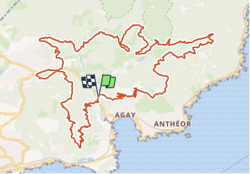

Length
41 km

Max alt
259 m

Uphill gradient
1017 m
Km-Effort
54 km

Min alt
4 m

Downhill gradient
1017 m
Boucle
Yes
Creation date :
2023-06-19 15:41:06.196
Updated on :
2023-06-19 15:41:06.196
3h45
Difficulty : Very difficult

FREE GPS app for hiking
 SityTrail
IGN / Geographical institutes
SityTrail Plus
The world is yours!
About
Trail Mountain bike of 41 km to be discovered at Provence-Alpes-Côte d'Azur, Var, Saint-Raphaël. This trail is proposed by topolino.
Positioning
Country:
France
Region :
Provence-Alpes-Côte d'Azur
Department/Province :
Var
Municipality :
Saint-Raphaël
Location:
Unknown
Start:(Dec)
Start:(UTM)
326046 ; 4812077 (32T) N.
Comments