


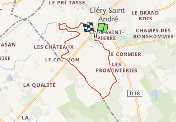
L'Ardoux, l'Arboretum, les Vivier, les Fromenteries et retour

Rembliere
User

Length
6.9 km

Max alt
101 m

Uphill gradient
39 m
Km-Effort
7.4 km

Min alt
85 m

Downhill gradient
38 m
Boucle
Yes
Creation date :
2023-06-19 20:56:24.46
Updated on :
2023-06-19 20:58:07.008
1h40
Difficulty : Easy

FREE GPS app for hiking
 SityTrail
IGN / Geographical institutes
SityTrail Plus
The world is yours!
About
Trail Walking of 6.9 km to be discovered at Centre-Loire Valley, Loiret, Cléry-Saint-André. This trail is proposed by Rembliere.
Positioning
Country:
France
Region :
Centre-Loire Valley
Department/Province :
Loiret
Municipality :
Cléry-Saint-André
Location:
Unknown
Start:(Dec)
Start:(UTM)
406619 ; 5296548 (31T) N.
Comments