


liaucous troglodytes eglasine st marcellin

Dan30
User
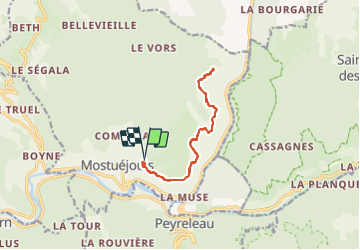

Length
13 km

Max alt
744 m

Uphill gradient
472 m
Km-Effort
19.3 km

Min alt
466 m

Downhill gradient
470 m
Boucle
Yes
Creation date :
2023-06-21 07:24:32.229
Updated on :
2023-06-21 13:08:51.329
3h42
Difficulty : Easy

FREE GPS app for hiking
 SityTrail
IGN / Geographical institutes
SityTrail Plus
The world is yours!
About
Trail Walking of 13 km to be discovered at Occitania, Aveyron, Mostuéjouls. This trail is proposed by Dan30.
Positioning
Country:
France
Region :
Occitania
Department/Province :
Aveyron
Municipality :
Mostuéjouls
Location:
Unknown
Start:(Dec)
Start:(UTM)
515530 ; 4894484 (31T) N.
Comments