


J2- Le Monastier-Le Bouchet

ghislainem
User
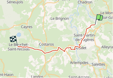

Length
21 km

Max alt
1229 m

Uphill gradient
638 m
Km-Effort
28 km

Min alt
763 m

Downhill gradient
374 m
Boucle
No
Creation date :
2023-06-21 06:17:37.519
Updated on :
2023-06-21 13:11:17.622
4h52
Difficulty : Very difficult

FREE GPS app for hiking
 SityTrail
IGN / Geographical institutes
SityTrail Plus
The world is yours!
About
Trail Walking of 21 km to be discovered at Auvergne-Rhône-Alpes, Haute-Loire, Saint-Martin-de-Fugères. This trail is proposed by ghislainem.
Description
J2- Le Monastier-Le Bouchet
Positioning
Country:
France
Region :
Auvergne-Rhône-Alpes
Department/Province :
Haute-Loire
Municipality :
Saint-Martin-de-Fugères
Location:
Unknown
Start:(Dec)
Start:(UTM)
575590 ; 4975068 (31T) N.
Comments