


La Champ (Arvieux) lac de Roue

taguette
User
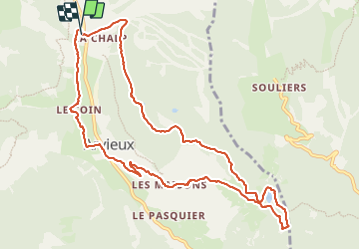

Length
11.7 km

Max alt
1929 m

Uphill gradient
438 m
Km-Effort
17.5 km

Min alt
1552 m

Downhill gradient
434 m
Boucle
Yes
Creation date :
2023-06-22 05:59:59.098
Updated on :
2023-06-22 09:00:55.531
2h58
Difficulty : Easy

FREE GPS app for hiking
 SityTrail
IGN / Geographical institutes
SityTrail Plus
The world is yours!
About
Trail Walking of 11.7 km to be discovered at Provence-Alpes-Côte d'Azur, Hautes-Alpes, Arvieux. This trail is proposed by taguette.
Positioning
Country:
France
Region :
Provence-Alpes-Côte d'Azur
Department/Province :
Hautes-Alpes
Municipality :
Arvieux
Location:
Unknown
Start:(Dec)
Start:(UTM)
320766 ; 4961226 (32T) N.
Comments