


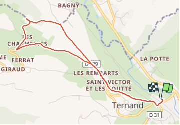
Ternand

chuck
User

Length
5.4 km

Max alt
425 m

Uphill gradient
183 m
Km-Effort
7.8 km

Min alt
274 m

Downhill gradient
183 m
Boucle
Yes
Creation date :
2023-06-22 07:46:43.888
Updated on :
2023-06-22 09:23:54.541
1h36
Difficulty : Medium

FREE GPS app for hiking
 SityTrail
IGN / Geographical institutes
SityTrail Plus
The world is yours!
About
Trail Walking of 5.4 km to be discovered at Auvergne-Rhône-Alpes, Rhône, Ternand. This trail is proposed by chuck.
Positioning
Country:
France
Region :
Auvergne-Rhône-Alpes
Department/Province :
Rhône
Municipality :
Ternand
Location:
Unknown
Start:(Dec)
Start:(UTM)
618944 ; 5089078 (31T) N.
Comments