


Moulin à tan

jcm17
User
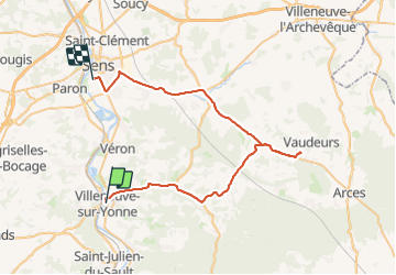

Length
49 km

Max alt
242 m

Uphill gradient
452 m
Km-Effort
55 km

Min alt
65 m

Downhill gradient
454 m
Boucle
No
Creation date :
2023-06-15 12:17:37.563
Updated on :
2023-06-22 19:50:28.701
2h21
Difficulty : Very difficult

FREE GPS app for hiking
 SityTrail
IGN / Geographical institutes
SityTrail Plus
The world is yours!
About
Trail Walking of 49 km to be discovered at Bourgogne-Franche-Comté, Yonne, Villeneuve-sur-Yonne. This trail is proposed by jcm17.
Positioning
Country:
France
Region :
Bourgogne-Franche-Comté
Department/Province :
Yonne
Municipality :
Villeneuve-sur-Yonne
Location:
Unknown
Start:(Dec)
Start:(UTM)
521824 ; 5325549 (31U) N.
Comments