


J4 Langogne- Luc

ghislainem
User
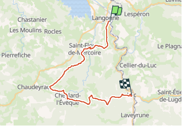

Length
27 km

Max alt
1237 m

Uphill gradient
728 m
Km-Effort
37 km

Min alt
932 m

Downhill gradient
662 m
Boucle
No
Creation date :
2023-06-23 05:00:27.61
Updated on :
2023-06-23 12:54:29.075
6h20
Difficulty : Very difficult

FREE GPS app for hiking
 SityTrail
IGN / Geographical institutes
SityTrail Plus
The world is yours!
About
Trail Walking of 27 km to be discovered at Occitania, Lozère, Langogne. This trail is proposed by ghislainem.
Positioning
Country:
France
Region :
Occitania
Department/Province :
Lozère
Municipality :
Langogne
Location:
Unknown
Start:(Dec)
Start:(UTM)
568146 ; 4952551 (31T) N.
Comments