


Burnos Aires 2

DECHAMPD
User
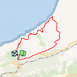

Length
8.1 km

Max alt
275 m

Uphill gradient
568 m
Km-Effort
15.6 km

Min alt
4 m

Downhill gradient
573 m
Boucle
Yes
Creation date :
2019-01-14 17:34:58.459
Updated on :
2019-01-14 17:34:58.519
3h09
Difficulty : Medium

FREE GPS app for hiking
 SityTrail
IGN / Geographical institutes
SityTrail Plus
The world is yours!
About
Trail Walking of 8.1 km to be discovered at Autonomous Community of the Basque Country, Gipuzkoa, Pasaia. This trail is proposed by DECHAMPD.
Description
départ du parking
Points of interest


Positioning
Country:
Spain
Region :
Autonomous Community of the Basque Country
Department/Province :
Gipuzkoa
Municipality :
Pasaia
Location:
Unknown
Start:(Dec)
Start:(UTM)
589214 ; 4798441 (30T) N.
Comments