


L'Amarron

soca
User
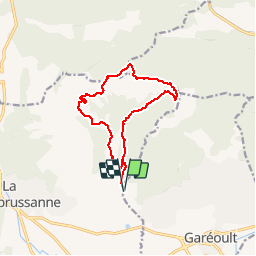

Length
13 km

Max alt
769 m

Uphill gradient
467 m
Km-Effort
19.3 km

Min alt
373 m

Downhill gradient
469 m
Boucle
Yes
Creation date :
2017-09-10 00:00:00.0
Updated on :
2017-09-10 00:00:00.0
4h30
Difficulty : Medium

FREE GPS app for hiking
 SityTrail
IGN / Geographical institutes
SityTrail Plus
The world is yours!
About
Trail Walking of 13 km to be discovered at Provence-Alpes-Côte d'Azur, Var, Garéoult. This trail is proposed by soca.
Positioning
Country:
France
Region :
Provence-Alpes-Côte d'Azur
Department/Province :
Var
Municipality :
Garéoult
Location:
Unknown
Start:(Dec)
Start:(UTM)
258118 ; 4802999 (32T) N.
Comments