


2023_05_27 Murs

clep.pietri
User
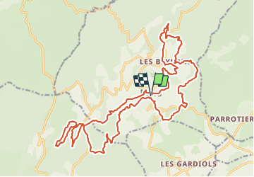

Length
30 km

Max alt
561 m

Uphill gradient
713 m
Km-Effort
39 km

Min alt
372 m

Downhill gradient
714 m
Boucle
Yes
Creation date :
2023-05-29 07:09:30.275
Updated on :
2023-06-24 18:52:09.129
3h27
Difficulty : Difficult

FREE GPS app for hiking
 SityTrail
IGN / Geographical institutes
SityTrail Plus
The world is yours!
About
Trail Mountain bike of 30 km to be discovered at Provence-Alpes-Côte d'Azur, Vaucluse, Murs. This trail is proposed by clep.pietri.
Positioning
Country:
France
Region :
Provence-Alpes-Côte d'Azur
Department/Province :
Vaucluse
Municipality :
Murs
Location:
Unknown
Start:(Dec)
Start:(UTM)
679936 ; 4868768 (31T) N.
Comments