


Marlhes Chaussitre L'allier Marlhes

psesjs
User
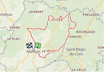

Length
17.2 km

Max alt
1244 m

Uphill gradient
526 m
Km-Effort
24 km

Min alt
841 m

Downhill gradient
526 m
Boucle
Yes
Creation date :
2023-06-07 07:09:06.04
Updated on :
2023-06-24 19:45:54.125
4h07
Difficulty : Easy

FREE GPS app for hiking
 SityTrail
IGN / Geographical institutes
SityTrail Plus
The world is yours!
About
Trail Walking of 17.2 km to be discovered at Auvergne-Rhône-Alpes, Loire, Marlhes. This trail is proposed by psesjs.
Positioning
Country:
France
Region :
Auvergne-Rhône-Alpes
Department/Province :
Loire
Municipality :
Marlhes
Location:
Unknown
Start:(Dec)
Start:(UTM)
609396 ; 5015322 (31T) N.
Comments