


Pamplinet col des Acles

taguette
User
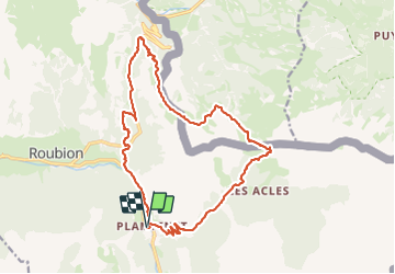

Length
20 km

Max alt
2289 m

Uphill gradient
1142 m
Km-Effort
35 km

Min alt
1482 m

Downhill gradient
1142 m
Boucle
Yes
Creation date :
2023-06-24 06:54:03.106
Updated on :
2023-06-25 05:35:34.082
7h16
Difficulty : Very difficult

FREE GPS app for hiking
 SityTrail
IGN / Geographical institutes
SityTrail Plus
The world is yours!
About
Trail Walking of 20 km to be discovered at Provence-Alpes-Côte d'Azur, Hautes-Alpes, Névache. This trail is proposed by taguette.
Positioning
Country:
France
Region :
Provence-Alpes-Côte d'Azur
Department/Province :
Hautes-Alpes
Municipality :
Névache
Location:
Unknown
Start:(Dec)
Start:(UTM)
315609 ; 4985943 (32T) N.
Comments