


Chalets et Granges de Furfande

Clo0413
User
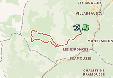

Length
14.3 km

Max alt
2295 m

Uphill gradient
692 m
Km-Effort
24 km

Min alt
1884 m

Downhill gradient
689 m
Boucle
Yes
Creation date :
2023-06-25 06:24:15.616
Updated on :
2023-06-27 12:34:20.109
4h55
Difficulty : Medium

FREE GPS app for hiking
 SityTrail
IGN / Geographical institutes
SityTrail Plus
The world is yours!
About
Trail Walking of 14.3 km to be discovered at Provence-Alpes-Côte d'Azur, Hautes-Alpes, Arvieux. This trail is proposed by Clo0413.
Positioning
Country:
France
Region :
Provence-Alpes-Côte d'Azur
Department/Province :
Hautes-Alpes
Municipality :
Arvieux
Location:
Unknown
Start:(Dec)
Start:(UTM)
321764 ; 4955259 (32T) N.
Comments