


Col du Vent St Michel d'Alajou Le Coulet

ARVIEU
User
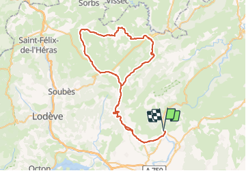

Length
79 km

Max alt
798 m

Uphill gradient
1437 m
Km-Effort
99 km

Min alt
60 m

Downhill gradient
1442 m
Boucle
Yes
Creation date :
2023-06-25 18:11:16.97
Updated on :
2023-06-25 18:13:52.703
4h00
Difficulty : Difficult

FREE GPS app for hiking
 SityTrail
IGN / Geographical institutes
SityTrail Plus
The world is yours!
About
Trail Cycle of 79 km to be discovered at Occitania, Hérault, Saint-Jean-de-Fos. This trail is proposed by ARVIEU.
Description
Départ Grotte de Clamouse, Col du Vent St Michel d'AlajouSt Maurice de Navacelles Le Coulet retour Clamouse par le Col du Vent
Positioning
Country:
France
Region :
Occitania
Department/Province :
Hérault
Municipality :
Saint-Jean-de-Fos
Location:
Unknown
Start:(Dec)
Start:(UTM)
544576 ; 4839842 (31T) N.
Comments