


pas bayard

veroberton
User
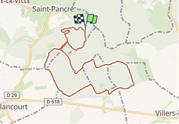

Length
10 km

Max alt
413 m

Uphill gradient
136 m
Km-Effort
11.8 km

Min alt
361 m

Downhill gradient
138 m
Boucle
Yes
Creation date :
2023-06-19 12:56:37.798
Updated on :
2023-06-26 07:27:45.135
3h01
Difficulty : Medium

FREE GPS app for hiking
 SityTrail
IGN / Geographical institutes
SityTrail Plus
The world is yours!
About
Trail Walking of 10 km to be discovered at Grand Est, Meurthe-et-Moselle, Saint-Pancré. This trail is proposed by veroberton.
Positioning
Country:
France
Region :
Grand Est
Department/Province :
Meurthe-et-Moselle
Municipality :
Saint-Pancré
Location:
Unknown
Start:(Dec)
Start:(UTM)
692559 ; 5489139 (31U) N.
Comments