


trans picardie trail baie de somme

olivieraron
User
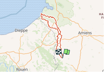

Length
218 km

Max alt
232 m

Uphill gradient
2043 m
Km-Effort
246 km

Min alt
0 m

Downhill gradient
2043 m
Boucle
Yes
Creation date :
2023-06-26 13:54:31.83
Updated on :
2023-06-27 05:33:08.187
6h40
Difficulty : Very easy

FREE GPS app for hiking
 SityTrail
IGN / Geographical institutes
SityTrail Plus
The world is yours!
About
Trail Moto cross of 218 km to be discovered at Hauts-de-France, Oise, Morvillers. This trail is proposed by olivieraron.
Points of interest


Positioning
Country:
France
Region :
Hauts-de-France
Department/Province :
Oise
Municipality :
Morvillers
Location:
Unknown
Start:(Dec)
Start:(UTM)
418601 ; 5492390 (31U) N.
Comments