


GR34-EtapeVIII-J06

JMCMoreau
User
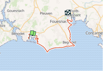

Length
23 km

Max alt
22 m

Uphill gradient
162 m
Km-Effort
25 km

Min alt
-1 m

Downhill gradient
160 m
Boucle
No
Creation date :
2023-06-26 16:09:35.066
Updated on :
2023-06-26 16:10:21.421
6h15
Difficulty : Medium

FREE GPS app for hiking
 SityTrail
IGN / Geographical institutes
SityTrail Plus
The world is yours!
About
Trail Walking of 23 km to be discovered at Brittany, Finistère, Bénodet. This trail is proposed by JMCMoreau.
Positioning
Country:
France
Region :
Brittany
Department/Province :
Finistère
Municipality :
Bénodet
Location:
Unknown
Start:(Dec)
Start:(UTM)
418893 ; 5301837 (30T) N.
Comments