


Col Agnel pic de Caramantran refuge de la Blanche 27 juin 2023

rlebasque
User
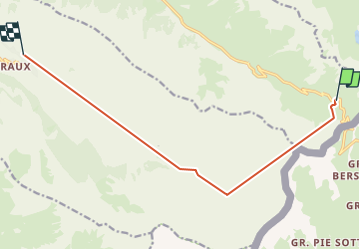

Length
11 km

Max alt
2976 m

Uphill gradient
628 m
Km-Effort
21 km

Min alt
2065 m

Downhill gradient
1182 m
Boucle
No
Creation date :
2023-06-27 06:24:31.596
Updated on :
2023-06-27 14:57:27.485
8h32
Difficulty : Very difficult

FREE GPS app for hiking
 SityTrail
IGN / Geographical institutes
SityTrail Plus
The world is yours!
About
Trail Walking of 11 km to be discovered at Provence-Alpes-Côte d'Azur, Hautes-Alpes, Molines-en-Queyras. This trail is proposed by rlebasque.
Positioning
Country:
France
Region :
Provence-Alpes-Côte d'Azur
Department/Province :
Hautes-Alpes
Municipality :
Molines-en-Queyras
Location:
Unknown
Start:(Dec)
Start:(UTM)
339638 ; 4950535 (32T) N.
Comments