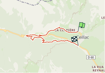
13.4 km | 26 km-effort
circuit des fours à chaux
marchev
User
Length
7 km
Max alt
1677 m
Uphill gradient
174 m
Km-Effort
9.3 km
Min alt
1536 m
Downhill gradient
197 m
Boucle
No
Creation date :
2023-06-28 08:45:32.607
Updated on :
2023-07-11 12:37:34.958
2h27
Difficulty : Easy
FREE GPS app for hiking
About
Trail Walking of 7 km to be discovered at Provence-Alpes-Côte d'Azur, Hautes-Alpes, Ceillac. This trail is proposed by marchev.
Description
Attention chemin coupé à 2 endroits mais il faut persévérer.
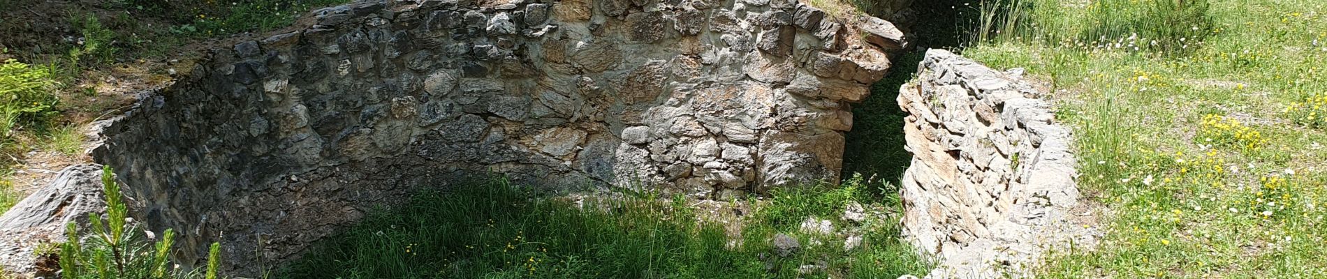
Passerelle branlante voir photo
Positioning
Country:
France
Region :
Provence-Alpes-Côte d'Azur
Department/Province :
Hautes-Alpes
Municipality :
Ceillac
Location:
Unknown
Start:(Dec)
Start:(UTM)
323652 ; 4948763 (32T) N.
Comments
Trails nearby
Crêtes de Chambrettes
Walking
Medium
(1)
Ceillac,
Provence-Alpes-Côte d'Azur,
Hautes-Alpes,
France
5h 53min
Yes
05 Tour Font Sancte - étape 1
Walking
Very difficult
(1)
Ceillac,
Provence-Alpes-Côte d'Azur,
Hautes-Alpes,
France
16.5 km | 36 km-effort
8h 9min
No
Ceillac - St Véran
Walking
Medium
Ceillac,
Provence-Alpes-Côte d'Azur,
Hautes-Alpes,
France
13.5 km | 28 km-effort
7h 22min
No
la pointe de la Saume (traversée)
Walking
Difficult
Ceillac,
Provence-Alpes-Côte d'Azur,
Hautes-Alpes,
France
15 km | 34 km-effort
6h 43min
No
Lac Ste Anne et Tête de Girardin
Walking
Medium
Ceillac,
Provence-Alpes-Côte d'Azur,
Hautes-Alpes,
France
14.4 km | 27 km-effort
5h 48min
Yes
lac Sainte Anne
Walking
Easy
(2)
Ceillac,
Provence-Alpes-Côte d'Azur,
Hautes-Alpes,
France
10.7 km | 17.9 km-effort
5h 16min
No
#1 Queyras 3j étape 1 Ceillac - Lac de Roue
Walking
Very difficult
Ceillac,
Provence-Alpes-Côte d'Azur,
Hautes-Alpes,
France
16.7 km | 33 km-effort
7h 34min
No
Arvieux Randonnée
Walking
Very difficult
Ceillac,
Provence-Alpes-Côte d'Azur,
Hautes-Alpes,
France
138 km | 250 km-effort
56h 55min
Yes
lac Saint Anne et Miroir
Walking
Medium
Ceillac,
Provence-Alpes-Côte d'Azur,
Hautes-Alpes,
France
10.9 km | 18.5 km-effort
4h 14min
Yes