


Cima delle Lose

Nicomontagnes
User
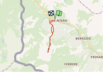

Length
12.2 km

Max alt
2778 m

Uphill gradient
1094 m
Km-Effort
27 km

Min alt
1695 m

Downhill gradient
1094 m
Boucle
Yes
Creation date :
2014-12-21 00:00:00.0
Updated on :
2014-12-21 00:00:00.0
4h16
Difficulty : Unknown

FREE GPS app for hiking
 SityTrail
IGN / Geographical institutes
SityTrail Plus
The world is yours!
About
Trail Other activity of 12.2 km to be discovered at Piemont, Cuneo, Argentera. This trail is proposed by Nicomontagnes.
Description
Ski de rando
Positioning
Country:
Italy
Region :
Piemont
Department/Province :
Cuneo
Municipality :
Argentera
Location:
Unknown
Start:(Dec)
Start:(UTM)
335573 ; 4918029 (32T) N.
Comments