


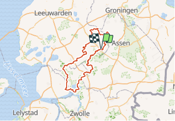
2023-06-29_08h34m24_kaart-01-38-Hoofdroute

mumu.larandonneuse
User GUIDE


54h33
Difficulty : Very difficult

FREE GPS app for hiking
 SityTrail
IGN / Geographical institutes
SityTrail Plus
The world is yours!
About
Trail Walking of 225 km to be discovered at Friesland, Unknown, Ooststellingwerf. This trail is proposed by mumu.larandonneuse.
Description
ℹ️ Long d’environ 260 km, le Stellingenpad vous emmènera dans de superbes endroits méconnus et féériques de la région des Stellingwerven. L’itinéraire passe par la Frise du sud-est, l’ouest de la Drenthe et les hauteurs de l’Overijssel. La randonnée compte 15 étapes de 12 à 28 km et traverse le réseau de points-nœuds du pays. Vous pourrez profiter de paysages variés, tels que des landes, des forêts et des abords de rivière. La nature vous fera vivre des aventures essentielles : se détendre et profiter de la nature.
Positioning
Comments